By car: Central Park is between 59th and 110th Sts and 5th and 7th Aves
(7th Ave = Central Park West). Parking is difficult everywhere, but
easier on Sundays on the East Side (e.g. Madison & E79th).
By subway: West side lines A/B/C/D are the closest with convenient
stops at 72nd and 79th streets, the 1/2/3 is slightly further away
with a convenient express stop at 72nd. On the East side the 4/5/6
stop at 59th St is the best, and the 6 stop at 68th St also useful.
Check the MTA subway map
By bus: numerous options. Download the
MTA Manhattan bus map
Nearby: Riverside Park
Riverside Park, Manhattan
Fort Tryon and the Cloisters, Manhattan
Battery Park, Manhattan
By car: West Side Drive to Battery Park or FDR Drive south to the same place.
You might be able to find parking at the financial center to the west of the West Side Drive,
but parking down near Wall St is very elusive indeed.
By subway: 6 to Brooklyn Bridge, 4/5 to Bowling Green, R to Whitehall-South Ferry, 1
to South Ferry
By bus: Download the
MTA Manhattan bus map
Nearby: Wagner Park and the other parks extending up the west side
Prospect Park, Brooklyn
By car: Atlantic Avenue south from the Brooklyn Bridge. Parking in Park Slope (west side of
park) is difficult but possible and the safest area.
By subway:
By bus:
Nearby: Greenwood Cemetery
Greenwood Cemetery, Brooklyn
Nearby: Prospect Park
Owl's Head Park, Brooklyn
Forest Park, Queens
Nearby: Jamaica Bay
Fort Tilden, Queens
Nearby: Riis Park, Breezy Point, Floyd Bennet Field, Jamaica Bay WR
Breezy Point, Queens
Nearby: Riis Park, Fort Tilden, Floyd Bennet Field, Jamaica Bay WR
Jamaica Bay Wildlife Refuge, Brooklyn/Queens
By car: Take the Cross Bay Boulevard exit off the Belt Parkway and go south, or take
Woodhaven Blvd south
from the Long Island Expressway (it becomes Cross Bay Blvd). Park at the refuge office.
By subway: the A subway line stops at Broad Channel, although sometimes construction work
reduces this to bus service (see
service advisories). Make sure to take the one going to the Rockaways (not Lefferts Blvd).
Check the MTA subway map.
The refuge is one mile north of the Broad Channel station along the main north-south highway.
By bus: it's not clear if the bus service along Cross Bay Blvd stops near the refuge or not
any more. Allegedly the Q21 and Q53 pass along there. See the
Queens bus map
Mount Loretto, Staten Island
By car:
By bus:
Rockland County
Sterling Forest
Palisades Parkway to I-87 to Route-17 (Tuxedo area) to
Orange County
Wallkill NWR
Only the Oil City Road section is in NY. Troublesome to get to, in the
general vicinity of Pine Island. Best approached from the west via local
roads from High Point State Park. From NYC, Palisades to I-87 to Rt-17
up through Tuxedo then take Rt-17A (winding, slow) alternatively stay
on I-87 to the Quickway exit (Rt-17) taking this to Goshen and then a
myriad of back roads (Pine Island, Eden - good map REQUIRED)
to Oil City road which parallels
the Orange Co/Sussex Co border just east of Unionville. Shorebirds in
flooded areas, Short-eared Owl in winter, waterfowl in migration.
Roads paralelling the Wallkill River on each side and some river
crossings also enter/pass parts of Wallkill NWR down into Sussex County.
Major congestion issues if you attempt to cut across Sussex Co toward
more central NJ.
New Jersey
Brigantine NWR
Bull's Island
Delaware Water Gap NRA
Sussex County
My favorite part of this area is Van Ness Rd, an unsigned road near Layton.
Take I-80 to the exit 25 for US Route 206. Follow US-206 north through Newton.
Keep following US-206 until you start to see signs for Stokes State Forest,
then watch for a Rt-560 signed for Layton and Dingman's Ferry (the toll
bridge to Pennsylvania over the Delaware). Follow Rt-560 through Layton.
Watch for Ridge Road on your right. About half a mile after Ridge Road the
un-named road to the right has a sign for Sandystown Twp Ball Fields. Take
this road. Good birds almost immediately, but the best
area is at the intersection of the gravel road leading to the
ball fields where "Van Ness Rd" swings hard left. Walk the
roads in all 4 directions. At the end of May, Golden-winged Warblers,
Alder Flycatchers, Yellow-breasted Chat etc can be found here. Golden-winged
Warblers appear to quiet down rapidly as you move into June. Beware of ticks.
Can return to Rt-560 and backtrack to Ridge Road ro intercept the
eastern end of Van Ness Rd by taking a left onto Van Ness about 1 mile up
Ridge Road. Park at the end of the lane near the gate and walk down to
the swamp (path often flooded at the bottom) which often has Willow and
Alder flycatchers. Ticks common here too.
Old Mine Road, extending north and south of Rt-560 right next to the
Delaware, is good for the same sort of species in the general area.
Probably also good south of Rt-560 toward Van Campen Inn but I've not
explored this.
Nearby locations are Stokes State Forest and High Point State Park. Deckertown
Pike, which leads to both, can be accessed from the northern end of Old Mine
Road at Montague, where it reaches US-206. Deckertown Pike is across US-206
from Old Mine Road.
Stokes State Forest
Take I-80 to exit 25 for US Route 206 north. Follow US-206 north nearly
all the way to the extreme NW corner of NJ. At Montague, shortly before you
reach the Delaware River and reach PA/NY, take a right onto Rt-650, Deckertown Pike, (opposite the end of Delaware Mine Road/Old Mine Road). After a few
miles along Rt-650, the road forks, with the smaller road to the right, Crigger
Road, signed as Stokes State Forest. Take Crigger Road into the state forest
ignoring the fork to the right, and following signs for Sawmill Campground.
Drive past the entrance to the campground and park at the small parking place
where the two-lane section of the road ends, and it becomes one-way (pointing
at you). The bridge is just beyond the parking place. Least Flycatcher and
Cerulean Warbler found at the parking place. Eastern Phoebe and
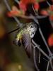
Ruby-throated Hummingbird found at the bridge. Black-throated Green
Warbler and Acadian Flycatcher found walking the trail downstream.
Nearby locations are Delaware Water Gap NRA and High Point State Park.
To get to High Point State Park return to Rt-650 and take a right, or take
a left and then make a right onto Sawmill Rd a couple of miles back (west)
along Rt-650. To get to Delaware Water Gap NRA, return to Rt-650 and follow
it west all the way to Rt-206, when the northern end of Old Mine Rd will
be across US-206 from you.
High Point State Park
One possibility: take I-80 to exit 25 and US-206 north to I-84,
I-84 north/east to Rt-23, Rt-23 south to High Point. This takes you to the
main park entrance at the summit on Rt-23. Gas stations and fast food where
Rt-23 reaches I-84. If around the Delaware
Water Gap NRA (Layton area) or Stokes State Forest one can take Sawmill
Road north from Deckertown Pike (Rt-650) toward Rt-23 which has been my
most productive road (Cerulean Warbler, Yellow-bellied Sapsucker, etc).
In the main park section (fee) accessed off the summit of Rt.23.
Kuser Bog is productive for higher elevation birds. I saw Blackburnian
Warbler singing there.
Alternative route via I-80 to Rt-23 via Wayne is probably longer and more
tedious and certainly with a lot more traffic on summer weekends.
Hoffman Farm Park
Hunterdon County
Take I-78 westbound most of the way to Pennsylvania. Get off at Exit 11.
Cross over the highway, making a left at the light, but do not enter the ramp
onto I-78. Continue 50 yards further along the frontage road along the
south side of I-78 and take a right onto Baptist Church Road. Travel
approximately a mile to the entrance to the park. Gates open 9am but you
can walk in through the locked gate before that.
Usual suspects: Grasshopper Sparrow, Bobolink, Willow Flycatcher, perhaps
Eastern Meadowlark. A Clay-colored Sparrow was found there in June 2005.
Hoffman Park site.
This is about 10 miles east of Oberly Rd/Alpha and about 15 miles north
of Frenchtown (e.g. Bull's Landing route).
Jake's Landing
Oberly Road, Alpha
I-78 westbound almost to the Del. Water Gap. Take exit 3, go north on
Rt-22 briefly and take Rt-122 west toward Alpha. Take Rt-519 south into
Alpha itself at a light. Take right onto "High St" at the first light.
Take this a mile or so to where it approaches I-78 and the road swings right
(north). Take a left onto Carpentersville Road at this point, and just
the other side of I-78 take a left onto Oberly Road (unmarked). About
0.75 miles along this road there is a small patch of grassland near a mail
box at the crest of the hill. Usual suspects: Grasshopper Sparrow, Horned
Lark, sometimes Vesper Sparrow, Longspur in winter.
This is fairly near Hoffman Park (~10 miles east) but not near much else.